 Bart Gawrych
Spatial in MariaDB are columns with the following data types: geometry, point, linestring, polygon, multipoint, multilinestring, multipolygon, geometrycollection
Note
If you are using MariaDB 10.1.2 or newer, you can use query obtaining spatial references system: MariaDB 10.1.2+ Query
Universal
The query below lists all columns with spatial data types.
Query
select col.table_schema as database_name,
       col.table_name,
       col.ordinal_position as column_id,
       col.column_name,
       col.data_type,
       col.is_nullable
from information_schema.columns col
join information_schema.tables tab
     on col.table_schema = tab.table_schema
     and col.table_name = tab.table_name
     and table_type = 'BASE TABLE'
where col.data_type in ('geometry', 'point', 'linestring', 'polygon',
                        'multipoint', 'multilinestring', 'multipolygon',
                        'geometrycollection')
      and col.table_schema not in ('information_schema', 'sys',
                                   'performance_schema', 'mysql')
     -- and table_schema = 'database_name' -- put your database name here
order by col.table_schema,
         col.table_name;
Columns
- database_name - name of the database (schema)
- table_name - name of the table
- column_id - column position in table
- column_name - name of the column
- data_type - type of data
- GEOMETRY
- POINT
- LINESTRING
- POLYGON
- MULTIPOINT
- MULTILINESTRING
- MULTIPOLYGON
- GEOMETRYCOLLECTION
- is_nullable - indicate whether column can contains null values
Rows
- One row represents one column with a spatial data type
- Scope of rows: all columns containing spatial data types in the database (schema)
- Ordered by database name and table name
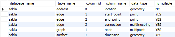
Sample results
MariaDB 10.1.2+
In this version of MariaDB introduced GEOMETRY_COLUMN and SPATIAL_REF_SYS tables.
Query
select g_table_schema as database_name,
       g_table_name as table_name,
       g_geometry_column as column_name,
       case geometry_type
            when 0 then 'GEOMETRY'
            when 1 then 'POINT'
            when 2 then 'LINESTRING'
            when 3 then 'POLYGON'
            when 4 then 'MULTIPOINT'
            when 5 then 'MULTILINESTRING'
            when 6 then 'MULTIPOLYGON'
            when 7 then 'GEOMETRYCOLLECTION'
            end as type,
       auth_name,
       auth_srid,
       srtext
from information_schema.geometry_columns col
join information_schema.spatial_ref_sys ref
     on col.srid = ref.srid
order by g_table_schema,
         g_table_name;
Columns
- database_name - name of the database (schema)
- table_name - name of the table
- column_name - name of the column
- type - geometry type of data
- GEOMETRY
- POINT
- LINESTRING
- POLYGON
- MULTIPOINT
- MULTILINESTRING
- MULTIPOLYGON
- GEOMETRYCOLLECTION
- auth_name - name of the standard or standards body that is being cited for reference system
- auth_srid - ID of the coordinate system in the above authority's catalog.
- srtext - Well-known Text Representation of the Spatial Reference System
Rows
- One row represents one column with a spatial data type
- Scope of rows: all columns containing spatial data types in the database (schema)
- Ordered by database name and table name
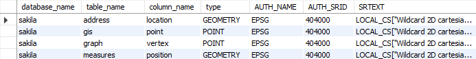
Sample results